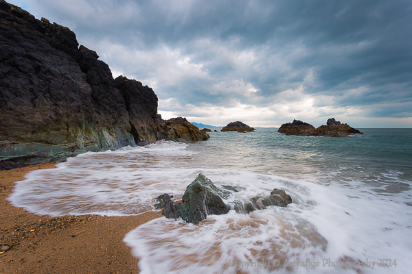
Ynys Llandwynd on the Isle of Anglesey in North Wales. A two mile hike across the beach from the Newborough coastal carpark. You can see the mainland of North Wales and Snowdonia (Yr Wyddfa), it is very close across the Menai Straits.

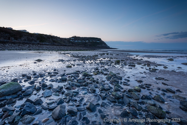
Rocks at Ynys Llanddwyn
On the edge of Newborough Dunes and forest, is ‘island’ Ynys Llanddwyn, which is still attached by raised dune causeway. The rocks have been created by underwater volcanoes and have left beautiful colours and striations. These are pillow lavas are part of the Precambrian Gwna Group. The tide was indecisively receding. the not quite detached island has views across to Snowdonia (Yr Wyddfa)

ISO100, f11, 1/13s 17mm, using a 0.3ND medium graduated filter

Lighthouse Tŵr Mawr
This lighthouse is the second one to be built on the peninsula in 1845, in the style of windmills of Anglesey. This island is situated to the entrance to the Menai Straits. The boom trade in slate required safe access the port at Bangor. Here you can see the mainland of North Wales, and the national park Snowdonia (Yr Wyddfa)

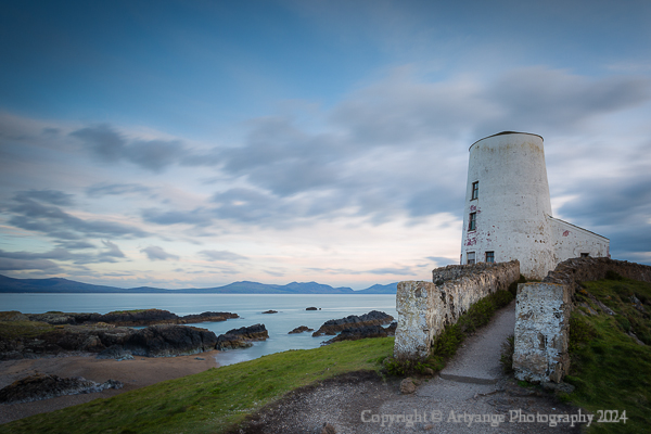
ISO100, f11, 15s, 20mm using a Lee mini stopper and 0.3ND medium graduated filter

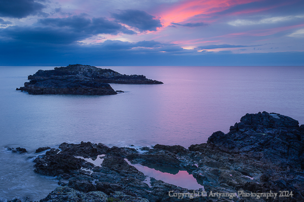
Sunset Yns Llanddwyn
A view from Tŵr Mawr, after a pretty grey afternoon we caught a glimpse of the sunsetting. a peeping eye of GORT on the seas horizon, with rocks providing the evening resting place for the seabirds. The two little yachts to the right. Its is the end of March and is still rather cool.

ISO100, f11, 1/6s, 19mm using a 0.3ND hard filter

Sunset Trails Ynys Llanddwyn
After the sun had dipped below the horizon, the sky changed dramatically, the clouds being light painted in red by the suns afterglow. This was nearly a missed opportunity, but I was determined not go away empty handed. The red clouds are like comets in the sky, with islets brought in a little closer.

ISO100, f11, 0.3s, 34mm using a 0.3ND hard filter

Sunset Rocks and Pools Llanddwyn
Pannng back out to capture the reflelection of the sky in the pool of water on the rocks on the peninsular. The sky turning pink before loosing the afterglow and light.

ISO100, f11, 1s, 35mm using a 0.3ND hard filter

Thanks for stopping by

Last of the Autumn at Ashgill Force

Ashgill Force is situated just north west of Teesdale near Alston in Cumbria. A road bridge traverses the waterfall. Ashgill Beck is a tributary to the South Tyne River less than a mile west down stream.

I visited this spot with my father, after an extended visit north to my see my parents. He suggested somewhere new to visit.

We parked up opposite the farm house, and walked through the farm near to the village Garrigill, following the path down to the gorge towards the river. After a few minutes walk, we popped our heads around a little corner to be greeted by this beautiful scene. The day was overcast leaving no sun shining through or blue skies even at sunrise. My dad spotted the old lead mineshaft entrance, but I was more interested in the waterfall. (Ashgill Force f/11 20mm 3.2s ISO100)

Ashgill Beck is a limestone river, and is striated with sandstone and shale. The fall leads to a series of smaller cascades within few hundred yards. We walked over the one man bridge to take in the scene around us.

The overcast weather lent itself to longer exposures without the use of the little or big stoppers. The photographs were shot at f11 for the depth of field, and using the Canon 14-40mm L series lens that I am accustomed to using, with various focal lengths.

Ashgill Beck Cascades

The vivid autumn reds and oranges were short lived this season, and left with vivid greens and browns. This particular shot I wanted to capture both bridges and the waterfalls. There were some great leading lines, I felt, that bring you into the shot. I used a medium graduated filter to help with the sky (Ashgill Waterfalls f/11 29mm 1.3s ISO100).

Further down stream, this waterfall felt secluded, flanked by the walls and trees, a low level shot brings it into the frame nicely. Here I could bring out the littles bits of oranges and browns with out too much green. I used a soft grad to balance out the image. (Ashgill Force Fall f/11 40mm 0.6s ISO100)

A little further down stream, a series of shelfs along the riverbed plateaued out. Keeping the falls in the shot heading back along the river. The water is crystal clear, I took advantage of the circular polariser with a soft grad. (Ashgill Waterfalls f/11 400mm 1s ISO100)

We went to the next cascade, this was a tricky vantage point, limited area to stand the tripod. I managed to get the small cascade above this drop in the the stream. We went no further, the light was getting too bright, and the weather was on the turn. (Ashgill Force Falls f/11 31mm 0.5s ISO100)

Thank you for stopping by. Wishing you all a happy new year.

A single oak tree in the field next to Ushaw College, near Bearpark. A long exposure using a Lee little stopper, f16, 2 minute exposure. Photographed in April 2022.

I took a closer look….

The picture on the left (Scarred Oak), the scar is appears to be like flame licking around the trunk, or could it be a leaping salmon?

The image on the right (Exposed Oak) has a lot going for it I think! It looks like some old diseased bone, the humerus and elbow. Look at those amazing knots in the centre, there is a wee heart shape, and I can see lots more in that; the top of it looks like a duck, the bottom of looks like a cats face. Above the heart shape I can see the Grinch, or is it a chipmunk?

What can you see?

Sorry I found something else to post! Again, thanks for stopping by

My usual return to place when I have not being doing much with the camera. I got up early, and went about to get a decent sunrise. The sunrise was not that glorious, and then I was little flummoxed with the composition approach. Usually with an expanse of water I struggle for foreground interest, and quite often it is hard to find something appealing. A note about the editing; some enhancement’s have been made, but I have kept as close as possible to the colours captured in camera.

Damflask Sunrise (F11 40mm 1/12s) A floating stick had meandered its way past and into the frame. After a breakwater from the Sheffield University rowing club, the stick had somehow lodged itself there in the frame.

Damflask Reservoir Sunrise (F11 22mm 1/20s). This rampart, not quite sure what it is, and I cannot find any information on, is visible due to the low levels of water. There is an access ramp down to the shore line, and normally you would not be able to stand here.

Damflask Jetty (F11 17mm 1/10s). My muse on the ‘Flask. Just below the boat house, and someway down the shore line, I always find myself photographing this, and to the amusement (I think} of the rowers coming in after there session. The sky had cleared a bit more of the cloud and some nice blue came through enough for me to use the polariser and a grad, hopefully to good effect.

Thanks for stopping by. Not sure when Ill be posting next!

While we were in Anglesey, back in April this year, we managed to visit two of the five lighthouses built around the island

South Stack Lighthouse

The first Lighthouse to be built on Anglesey in 1809 on the summit of Ynys Lawd
A nature reserve is situated near the lighthouse. April is a good time to view the guillemots and the puffins arriving to the shore of the UK.
A pod of dolphins reside in the waters around the lighthouse.
To get the lighthouse you have descend 400 steps, over a bridge, which originally you had go via a basket until 1828

Trwyn Du Lighthouse Penmon Point

Built in 1838 to mark the north entrance into the Menia Straits. On the lighthouse it is marked ‘NO PASSASGE LANDWARD’, to prevent maritime traffic from being stranded on the rocks. At high tide the rocks are hidden.
The lighthouse marks the point between Black Point (Trwyn Du) and Puffin Island (Ynys Seriol).
It can only be accessed at low tide.

Photographed using a Canon 6D, 17- 40mm L series lens with Lee ND grad filters.

Isle of Anglesey on the north west coast of Wales is joined by two bridges over the Menai Straits. The original suspension bridge Menai Bridge was completed in 1824. The second bridge the Britannia Bridge, was built in 1850 as train bridge by Robert Louis Stephenson

Benllech

Benllech is the 4th largest settlement village on Anglesey, residing on the east coast of the island.
Benllech is a derivative of the word penllech meaning head slab or head rock.

We visited The Bay Cafe for a wonderful mid morning breakfast, and is located next the beach and has a lovely view over the beach and sea. The beach is popular swimmers and walkers, a great beach to play on when the tide is out. Fishermen beach cast in the evenings.

A series of pictures taken over 4 evenings on the beach at Benllech. Three images photographed from each night showing the differing light and atmospheric conditions at sunset.

Photographed using Canon 6D 17-40mm L series lens, using various Lee filters, mostly medium grads and a Lee Little Stopper Benllech Beach Sunset Rocks II, the penultimate image in the gallery, exposed for 2 minutes.

With thanks to the friends (the Hughes and Magrill) who allowed us to stay in their bungalow for a short holiday back In April.

Thanks for stopping by.

Create a free website or blog at WordPress.com.

Up ↑